Case Study: Vermont Air National Guard Uses Polhemus SCOUT in F-16 Simulators
The Vermont Air National Guard (ANG) uses over 90 MetaVR™ Virtual Reality Scene Generator™ (VRSG)™ licenses in their four-ship simulators at the new F-16 Mission Training Center (MTC) located at the VT Air National Guard (ANG) facilities at the Burlington International Airport, Burlington, VT.
-f.jpg) The F-16 MTC officially opened on June 4, 2010 with a ceremony that included U.S. Sen. Patrick Leahy, Lt. Gen. Christopher D. Miller, the Air Force's deputy chief of staff for strategic plans and programs, and top National Guard officials. MetaVR and International Simulation & Training Systems (ISTS, the subcontractor that built the simulators) were given awards for engineering excellence.
The F-16 MTC officially opened on June 4, 2010 with a ceremony that included U.S. Sen. Patrick Leahy, Lt. Gen. Christopher D. Miller, the Air Force's deputy chief of staff for strategic plans and programs, and top National Guard officials. MetaVR and International Simulation & Training Systems (ISTS, the subcontractor that built the simulators) were given awards for engineering excellence.
Figure 1: One of four cockpit simulators at the new F-16 MTC, located at the ANG base at the Burlington International Airport, Burlington, VT. The multi-channel synchronized view, driven by VRSG, is rendering the VT virtual terrain built by MetaVR. Photo courtesy of MetaVR; photo credit to SSgt. Dan DiPetro, 158 FW, Vermont National Guard.
About the Simulators
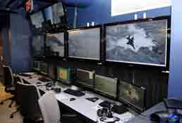 The site consists of four F-16 full mission trainers, instructor/operator stations (IOS) for each cockpit, and an after-action review capability. Each cockpit consists of a 360-degree wraparound display based on the A-10C FMT seamless M2-DART display. The original M2-DART display used one projector for each of the eight display facets. The contractor team enhanced this design by using two or three projectors on each of the eight display facets, for a total of 18 HD projectors.
Figure 2: Inside the new F-16 MTC, located at the ANG base at Burlington International Airport, Burlington, VT. Photo courtesy of MetaVR; photo credit to SSgt. Dan DiPetro, 158 FW, Vermont National Guard.
Inside the wraparound display sets a high-fidelity cockpit with functional buttons, switches, and multi-function displays (MFDs). The MFDs can display targeting pod video in electro-optic (EO), infrared (IR), or ground-mapping radar. An instructor/operator station (IOS) exists for each cockpit. The IOS establishes the environment the simulator will fly in, to include geographic location, weather, and time-of-day. The IOS also controls the threat environment using the AFRL XCITE target generator. The IOS includes a large flat-screen TV that can simultaneously display a replica of out-the window scene, heads-up display, and both multi-function displays.
Unique to this installation is its novel approach to night vision goggle (NVG) training. The visual system uses a stimulate approach rather than simulate approach to NVG training. The pilot wears his real NVGs while in the cockpit, so he can become accustomed to the form-factor and limited field-of-view.
Using the Polhemus SCOUT tracker, the pilot is head-tracked with 6 degrees-of-freedom, enabling the image generator to know at any moment the exact location and viewing direction of the pilot's head.
The Polhemus SCOUT tracker is an AC magnetic head tracker that requires no mapping effort to run at high accuracy within the full mission simulators. The image generator renders an NVG area of interest (AOI) inside a cone visible to the goggles. Imagery rendered inside the NVG AOI is modified to stimulate NVGs and display covert lights. Imagery rendered outside the NVG AOI is rendered as normal unaided-eye, and covert lights are not visible outside the NVG AOI. This forces the pilots to look through the NVGs to be able to see the scene in sufficient detail at night for flying.
About the VT ANG Database
MetaVR has built and delivered to the Vermont Air National Guard 3D terrain of the ANG base facilities and airfield at the Burlington International Airport, Burlington, VT.
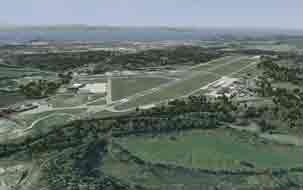 The 6-geocell Metadesic-formatted 3D terrain, built with MetaVR's Terrain Tools for ArcGIS is comprised of 47 GB of data of Vermont and upstate New York, with 60-meters post spacing, 1-meter imagery with a 0.5-meter imagery inset of the Vermont Air National Guard airfield and base facilities. The Vermont Air National Guard uses the terrain for its F-16C simulation-based training. Figure 3: Real-time aerial view in VRSG of the virtual Vermont ANG base and airfield, with Lake Champlain visible in the background. Photo courtesy of MetaVR
About the Models
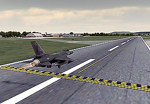 The virtual terrain contains approximately 45-high resolution, geolocated models of hangars, offices, storage facilities, and other buildings in the area, a high-resolution F-16C aircraft model, and the runway. In addition, the virtual terrain includes the commercial air terminal, and approximately 40 other models of elements at Burlington International Airport such as runway lights, street light, signs, and trees. Figure 4: Real-time VRSG rendering of an F-16 entity taking off from the runway of the virtual Vermont ANG airfield. Photo courtesy of MetaVR
All site-specific models were created with textures derived from high-resolution photographs taken at the site, at ground level, with a 10-megapixel camera. The models were built with industry standard 3D modeling tools such as Autodesk, Maya and 3D Studio Max. Content from MetaVR's 3D model libraries is also used on the terrain.
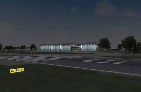 For simulating night scenes, the terrain contains thousands of cultural light points of the airport and the Greater Burlington area. VSRG has an ephemeris model to predict moon position and phase, and populates the sky with a 40,000 light-point star field. The cultural lights, moon disk, and star field enable trainees in the cockpit simulator to fly the area at night with accurate celestial references and provide realistic simulation of actual night vision goggles. Figure 5: View at dusk of the hangar, from across the runway. Photo courtesy of MetaVR
To geolocate many of the elements on the airfield terrain to match the ones on the actual airfield itself, an interactive panoramic view was created from photos taken at the site as a reference, using photo-stitching software.
MetaVR Terrain Tools for ESRI ArcGIS was used to create the terrain mesh, which includes a high resolution representation of the Lake Champlain coastline. At runtime, VRSG Metadesic generates multi-textured, animated, normal-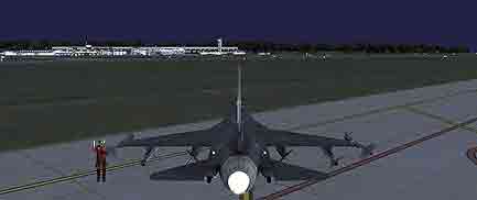 mapped water surfaces in the cutout regions identified as water. The terrain tiles seamlessly match with the water tiles generated by VRSG. Figure 6: Night scene of the commercial terminal at the virtual Burlington International Airport. Photo courtesy of MetaVR

Figure 7: The panoramic view was mapped onto a 3D cylindrical model, resulting in a 360 degree virtual view, or model that could be examined as a reference for placing models on the terrain. Photo courtesy of MetaVR
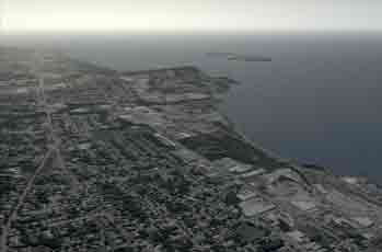
Figure 8: VRSG real-time aerial view of the virtual shoreline region of Lake Champlain, Burlington, Vermont. Photo courtesy of MetaVR
Learn More:
- SCOUT
- Download PDF
- Contact sales@polhemus.com for more information.

